Hiking tour

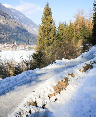
Valley hiking trail "Via Claudia Augusta" section Prutz - Fließ

From Prutz this hike leads over the bridge to the Entbruck district. The path leads right to the Pontlatzbrücke bridge, from there immediately left along the Inntalradweg to the power station, then take the stairs on the right and cross the main road. It follows a cart path to Fließ on the right (signposted).
324m
6.9km
Highest point
1071m
Start point
Prutz
End point
Fließ

Similar Tours

Medium
400m | 8.7km
Hiking tour
Trail - Parcour - Mutzkopfrunde
Begin: Talstation Mutzkopflift
End: Gasthof Martha
Easy
16m | 1h | 3.5km
Hiking tour
Wanderung über Wanderweg 9c zum Riatschhof
Begin: Bergstation Mutzkopfsessellift
End: Nauders Dorf
Medium
760m | 5h | 8.8km
Hiking tour
Große Verpeilrunde
Begin: Feichten
End: Verpeilhütte
Medium
769m | 8h | 18.3km
Hiking tour
Kobler Alm - Bergwiesen - Hahntennenberg - Ochsenberg
Begin: Parkplatz Kobler Alm
End: Infobüro Pfunds
Difficult
609m | 4h | 5.8km
Hiking tour
Zaunhof - Kaunerberg
Begin: Zaunhof
End: Kaunerberg
Easy
160m | 2.5h | 6.5km
Hiking tour
Harberundwanderung über Harbe Weiher
Begin: Naturparkhaus Kaunergrat
End: Naturparkhaus Kaunergrat
Medium
860m | 10h | 8.7km
Hiking tour
Roter Schrofen (2.702m) und Mittagskopf (2.616m)
Begin: Infobüro Kaunertal
End: Infobüro Kaunertal
Medium
263m | 2h | 4.4km
Hiking tour
Rundwanderung Ögghöfe
Begin: Infobüro Kaunertal
End: Infobüro Kaunertal